1. Narayan K., Khanindra P., Abhisek C., et al. Forest health assessment for geo-environmental planning and management in hilltop mining areas using Hyperion and Landsat data // Ecological Indicators. 2019. Vol. 106. P. 105471. 10.1016/j.ecolind.2019.105471. (https://www.sciencedirect.com/science/article/abs/pii/S1470160X1930456X). DOI: 10.1016/j.ecolind.2019.105471.( EDN: SFXIWR
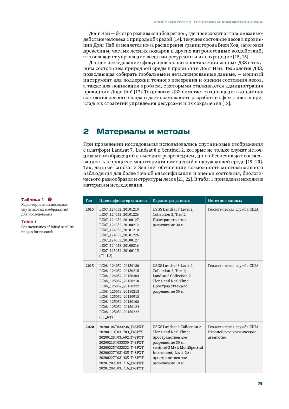
2. Paal T., Zobel K., Liira J. Standardized response signatures of functional traits pinpoint limiting ecological filters during the migration of forest plant species into wooded corridors // Ecological Indicators. 2020. Vol. 108. P. 105688. 10.1016/j.ecolind.2019.105688. (https://www.sciencedirect.com/science/article/abs/pii/S1470160X19306818). DOI: 10.1016/j.ecolind.2019.105688.( EDN: YGPNUC
3. Pham V.T., Do T.A.T., Tran D.H., Do T.N.A. Classifying forest cover and mapping forest fire susceptibility in Dak Nong province, Vietnam utilizing remote sensing and machine learning // Ecological Informatics. 2023. Vol. 79. P. 102392. https://www.sciencedirect.com/science/article/pii/S1574954123004211?via%3Dihub). DOI: 10.1016/j.ecoinf.2023.102392.(
4. Баникевич Т.Д., Быкова Е.Н. Кадастровая оценка земель сельскохозяйственного использования и оценка качества почв: взаимосвязь и перспективы // Journal of Agriculture and Environment. 2023. T. 33. № 5. 10.23649/JAE.2023.33.6. (https://jae.cifra.science/archive/5-33-2023-may/10.23649/JAE.2023.33.6). DOI: 10.23649/JAE.2023.33.6.(
5. Матрохина К.В., Трофимец В.Я., Мазаков Е.Б. и др. Развитие методологии сценарного анализа инвестиционных проектов предприятий минерально-сырьевого комплекса // Записки Горного института. 2023. № 259. С. 112-124. 10.31897/PMI.2023.3. (https://pmi.spmi.ru/index.php/pmi/article/view/15829?setLocale=ru_RU). DOI: 10.31897/PMI.2023.3.( EDN: DBXKMW
6. Лепихина О.Ю., Правдина Е.А. Вариативный учет ценообразующих факторов при кадастровой оценке земель (на примере города Санкт-Петербурга) // Известия Томского политехнического университета. Инжиниринг георесурсов. 2019. T. 2. №330. С. 65-74. 10.18799/24131830/2019/2/94. (https://izvestiya.tpu.ru/archive/article/view/94). DOI: 10.18799/24131830/2019/2/94.( EDN: YXZNJB
7. Бузмаков С.А., Санников П.Ю., Кучин Л.С. др. Применение беспилотной аэрофотосъемки для диагностики техногенной трансформации природной среды при эксплуатации нефтяного месторождения // Записки Горного института. 2023. Т. 260. С. 180-193. 10.31897/PMI.2023.22 (https://pmi.spmi.ru/pmi/article/view/16039?setLocale=ru_RU). DOI: 10.31897/PMI.2023.22( EDN: OYQTDS
8. Ковязин В.Ф., Нгуен Ч.А., Нгуен Т.Ч. Мониторинг земель лесного фонда провинции Кон Тум Вьетнама по данным дистанционного зондирования Земли // Геодезия и картография. 2023. Т. 84. №8. С. 57-64. 10.22389/0016-7126-2023-998-8-57-64. (https://geocartography.ru/scientific_article/2022_6_54-63). DOI: 10.22389/0016-7126-2023-998-8-57-64.( EDN: ZNMITL
9. Chepyzhova A.V., Pravdina E.A., Lepikhina O.Y. Comparative evaluation of the effectiveness of the laser scanning and aerial photography systems using unmanned aerial vehicles // Journal of Physics: Conference Series. 2019. Vol. 1333. P. 032064. 10.1088/1742-6596/1333/3/032064. (https://iopscience.iop.org/article/10.1088/1742-6596/1333/3/032064). DOI: 10.1088/1742-6596/1333/3/032064.( EDN: MYWWLK
10. Bykowa E., Skachkova M., Raguzin I., et al. Automation of Negative Infrastructural Externalities Assessment Methods to Determine the Cost of Land Resources Based on the Development of a “Thin Client” Model // Sustainability. 2022. Vol.14. P. 9383. 10.3390/su14159383. (https://www.mdpi.com/2071-1050/14/15/9383). DOI: 10.3390/su14159383.( EDN: VSQVOJ
11. Потехин Д.В., Галкин С.В. Применение технологии машинного обучения при моделировании распределения литотипов на пермокарбоновой залежи нефти Усинского месторождения // Записки Горного института. 2023. Т. 259. С. 41-51. 10.31897/PMI.2022.101. (https://pmi.spmi.ru/pmi/article/view/15935?setLocale=ru_RU). DOI: 10.31897/PMI.2022.101.( EDN: ANYBFD
12. Baltyzhakova T.L., Romanchikov A. Spatial analysis of subway passenger traffic in Saint Petersburg // Geodesy and Cartography. 2021. Vol.47. P. 10-20. 10.3846/gac.2021.11980. (https://journals.vilniustech.lt/index.php/GAC/article/view/11980). DOI: 10.3846/gac.2021.11980.(
13. Rossi F., Breidenbach J., Puliti S., et al. Assessing Harvested Sites in a Forested Boreal Mountain Catchment through Global Forest Watch // Remote Sensing. 2019. Vol. 11. P. 543. 10.3390/rs11050543. (https://www.mdpi.com/2072-4292/11/5/543). DOI: 10.3390/rs11050543.(
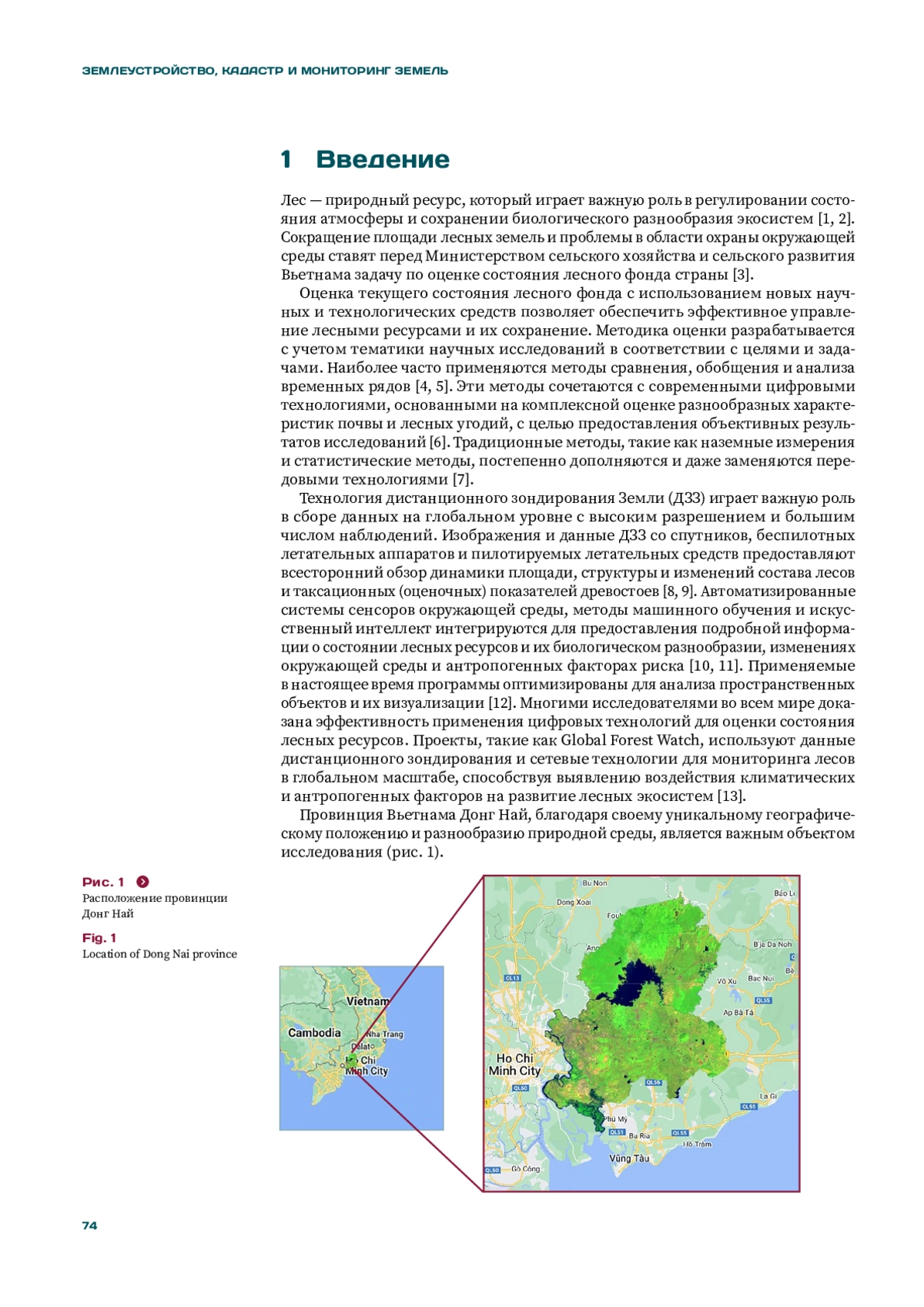
14. Данг В.Х., Фан В.З., Потокин А.Ф. Разнообразие лекарственных растений в составе лесной растительности на территории заповедника «Донг Най», Вьетнам // Известия Санкт-Петербургской лесотехнической академии. 2019. №227. С. 107-122. 10.21266/2079-4304.2019.227.107-122. (https://www.researchgate.net/publication/344795101_Diversity_of_medicinal_plants_in_the_composition_forestry_vegetation_on_the_territory_of_reserve_Dong_Nai_Vietnam). DOI: 10.21266/2079-4304.2019.227.107-122.( EDN: YHJYTK
15. Verma S., Soni M., Kumar H., et al. Characterizing aerosols during forest fires over Uttarakhand region in India using multi-satellite remote sensing data // Advances in Space Research. 2022. Vol.70. P. 947-960. 10.1016/j.asr.2022.05.051. (https://www.sciencedirect.com/science/article/abs/pii/S027311772200432X). DOI: 10.1016/j.asr.2022.05.051.( EDN: GIMLFY
16. Camarretta N., Harrison P., Bailey T., et al. Monitoring forest structure to guide adaptive management of forest restoration: a review of remote sensing approaches // New Forests. 2020. Vol. 51. P. 573-596. 10.1007/s11056-019-09754-5. (https://link.springer.com/article/10.1007/s11056-019-09754-5). DOI: 10.1007/s11056-019-09754-5.( EDN: JJCRWP
17. Paudyal K., Samsudin Y.B., Baral H., et al. Spatial Assessment of Ecosystem Services from Planted Forests in Central Vietnam // Forests. 2020. Vol. 11. P. 822. 10.3390/f11080822. (https://www.mdpi.com/1999-4907/11/8/822). DOI: 10.3390/f11080822.( EDN: UUGPFR
18. Корнилов Ю.Н., Романчиков А.Ю., Боголюбова А.А. Оценка деформационных процессов фотограмметрическим способом в Agisoft Metashape // Геодезия и картография. 2023. №10. С. 2-11. 10.22389/0016-7126-2023-1000-10-2-11. (https://geocartography.ru/sites/default/files/gik/2023.10.pdf). DOI: 10.22389/0016-7126-2023-1000-10-2-11.( EDN: DUKIWN
19. Chen N., Tsendbazar N.E., Hamunyela E., et al. Sub-annual tropical forest disturbance monitoring using harmonized Landsat and Sentinel-2 data // International Journal of Applied Earth Observation and Geoinformation. 2021. Vol. 102. P. 102386. 10.1016/j.jag.2021.102386. (https://www.sciencedirect.com/science/article/pii/S0303243421000933). DOI: 10.1016/j.jag.2021.102386.(
20. Arévalo P., Baccini A., Woodcock C.E., et al. Continuous mapping of aboveground biomass using Landsat time series // Remote Sensing of Environment. 2023. Vol. 288. P. 113483. 10.1016/j.rse.2023.113483. (https://www.sciencedirect.com/science/article/abs/pii/S0034425723000342). DOI: 10.1016/j.rse.2023.113483.( EDN: GVGIFB
21. Li H., Zhang G., Zhong Q., et al. Prediction of Urban Forest Aboveground Carbon Using Machine Learning Based on Landsat 8 and Sentinel-2: A Case Study of Shanghai, China // Remote Sensing. 2023. Vol. 15. P. 284. 10.3390/rs15010284. (https://www.mdpi.com/2072-4292/15/1/284). DOI: 10.3390/rs15010284.(
22. Zeng Y., Wang S., Zhao T., Wang J. An application of tree species classification using high-resolution remote sensing image based on the rough set theory // Multimedia Tools and Applications. 2017. Vol. 76. P. 22999-23015. 10.1007/s11042-016-4210-8. (https://link.springer.com/article/10.1007/s11042-016-4210-8). DOI: 10.1007/s11042-016-4210-8.(
23. Zhao J., Peng H., Yang J., et al. Response of winter wheat to different drought levels based on Google Earth Engine in the Huang-Huai-Hai Region, China // Agricultural Water Management. 2024. Vol. 292. P. 108662. 10.1016/j.agwat.2023.108662. (https://econpapers.repec.org/article/eeeagiwat/v_3a292_3ay_3a2024_3ai_3ac_3as0378377423005279.htm). DOI: 10.1016/j.agwat.2023.108662.( EDN: WIICTK
24. Zurqani H.A. The first generation of a regional-scale 1-m forest canopy cover dataset using machine learning and google earth engine cloud computing platform: A case study of Arkansas, USA // Data in Brief. 2024. Vol. 52. P. 109986. 10.1016/j.dib.2023.109986. (https://pubmed.ncbi.nlm.nih.gov/38293581/). DOI: 10.1016/j.dib.2023.109986.( EDN: MRXHQC
25. Prasad P., Loveson V.J., Chandra P., Koth M. Evaluation and comparison of the earth observing sensors in land cover / land use studies using machine learning algorithms // Ecological Informatics. 2022. Vol. 68. P. 101522. 10.1016/j.ecoinf.2021.101522. (https://colab.ws/articles/10.1016/j.ecoinf.2021.101522). DOI: 10.1016/j.ecoinf.2021.101522.( EDN: DITQUG
26. Sanchez L.M., See L., Yordanov M., et al. Automatic classification of land cover from LUCAS in-situ landscape photos using semantic segmentation and a Random Forest model // Environmental Modelling & Software. 2024. Vol. 172. P. 105931. 10.1016/j.envsoft.2023.105931. (https://www.sciencedirect.com/science/article/pii/S1364815223003171?via%3Dihub). DOI: 10.1016/j.envsoft.2023.105931.(
27. Li M., Gao Q., Yu T. Using appropriate Kappa statistic in evaluating inter-rater reliability. Short communication on “Groundwater vulnerability and contamination risk mapping of semi-arid Totko river basin, India using GIS-based DRASTIC model and AHP techniques” // Chemosphere. 2023. Vol. 328. P. 138565. 10.1016/j.chemosphere.2023.138565. (https://pubmed.ncbi.nlm.nih.gov/37011819/). DOI: 10.1016/j.chemosphere.2023.138565.( EDN: IBJVIU
28. Foody G.M. Explaining the unsuitability of the kappa coefficient in the assessment and comparison of the accuracy of thematic maps obtained by image classification // Remote Sensing of Environment. 2020. Vol.239. P. 111630. 10.1016/j.rse.2019.111630. (https://www.sciencedirect.com/science/article/abs/pii/S0034425719306509?via%3Dihub). DOI: 10.1016/j.rse.2019.111630.( EDN: WGFJYS
29. Скачкова М.Е., Гурьева О.С. Мониторинг состояния зеленых насаждений Санкт-Петербурга по материалам дистанционного зондирования // Экология и промышленность России. 2023. Т. 27. № 5. С. 51-57. 10.18412/1816-0395-2023-5-51-57. (https://www.ecology-kalvis.ru/jour/article/view/2380). DOI: 10.18412/1816-0395-2023-5-51-57.( EDN: LKELSR
30. Xu Y., Dai Q.Y., Lu Y.G., et al. Identification of ecologically sensitive zones affected by climate change and anthropogenic activities in Southwest China through a NDVI-based spatial-temporal model // Ecological Indicators. 2024. Vol. 158. P. 111482. 10.1016/j.ecolind.2023.111482. (https://www.sciencedirect.com/science/article/pii/S1470160X23016242?via%3Dihub). DOI: 10.1016/j.ecolind.2023.111482.( EDN: KYHNKL
31. Чукаева М.А., Сапелко Т.В. Оценка экологического состояния водных экосистем по изучению донных отложений озер // Записки Горного института. 2024. С. 1-10.
32. Ma S., He B., Ge X., Luo X. Spatial prediction of soil salinity based on the Google Earth Engine platform with multitemporal synthetic remote sensing images // Ecological Informatics. 2023. Vol. 75. P. 102111. 10.1016/j.ecoinf.2023.102111. (https://www.sciencedirect.com/science/article/abs/pii/S1574954123001401?via%3Dihub). DOI: 10.1016/j.ecoinf.2023.102111.( EDN: GEQNUS
33. Rashid B., Sheik R., Haque E., et al. Salinity-induced change in green vegetation and land use patterns using remote sensing, NDVI, and GIS techniques: A case study on the southwestern coast of Bangladesh // Case Studies in Chemical and Environmental Engineering. 2023. Vol. 7. P. 100314. 10.1016/j.cscee.2023.100314. (https://www.sciencedirect.com/science/article/pii/S2666016423000191?via%3Dihub). DOI: 10.1016/j.cscee.2023.100314.( EDN: STGEIQ
34. Sun Z., Wang G., Li P., et al. An improved random forest based on the classification accuracy and correlation measurement of decision trees // Expert Systems with Applications. 2024. Vol. 237. P. 121549. 10.1016/j.eswa.2023.121549. (https://www.sciencedirect.com/science/article/abs/pii/S0957417423020511?via%3Dihub). DOI: 10.1016/j.eswa.2023.121549.( EDN: UQEUOG
35. Eddine H.K., Saleh S., Hajjar J., et al. Evaluation of the accuracy of new modalities in the assessment and classification of lumbar lordosis: A comparison to Cobb’s angle measurement // Heliyon. 2023. Vol. 9. P. e18952. 10.1016/j.heliyon.2023.e18952. (https://www.cell.com/heliyon/pdf/S2405-8440(23)06160-1.pdf). DOI: 10.1016/j.heliyon.2023.e18952.( EDN: SACXKN